Deadly Storms Sweep Across Pennsylvania: A Closer Look at Severe Weather’s Impact
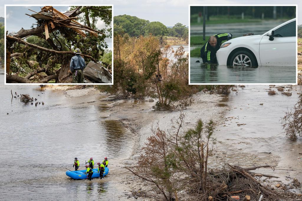
Powerful storms tore through Pennsylvania this week, leaving at least five dead, dozens injured, and widespread destruction in their wake. The severe weather system, which battered the Midwest and East Coast from Tuesday through Thursday, unleashed tornadoes, flash floods, and hurricane-force winds exceeding 80 mph. Emergency crews continue search-and-rescue operations as meteorologists link the extreme conditions to a collision of warm, moist air with an unusually strong cold front.
Immediate Aftermath and Emergency Response
In hardest-hit Bucks County, first responders worked through the night to clear downed trees from roads and restore power to over 120,000 households. The National Weather Service confirmed three EF-2 tornadoes touched down across the state, with one carving a 12-mile path of destruction through suburban neighborhoods.
“This is some of the most significant storm damage I’ve seen in 15 years of emergency management,” said Bucks County Office of Emergency Management Director Scott Forster. “The combination of straight-line winds and tornadic activity created a perfect storm scenario that overwhelmed local infrastructure.”
Key impacts include:
- 5 confirmed fatalities (3 from flash flooding, 2 from structural collapses)
- 37 hospitalizations reported across 6 counties
- Estimated $50-75 million in property damage
- 15 school districts closed for multiple days
Meteorological Factors Behind the Severe Weather
Climate scientists point to several converging factors that intensified the storm system. A high-pressure dome over the Southeast collided with a deep low-pressure trough moving eastward from the Great Lakes, creating ideal conditions for supercell thunderstorms.
Dr. Elena Rodriguez, a severe weather researcher at Penn State University, explained: “We’re seeing atmospheric patterns typically observed in late spring occurring in early summer. The jet stream’s unusual positioning provided continuous energy to these storms, while record-high sea surface temperatures along the Atlantic coast added exceptional moisture.”
Notable weather records broken during the event:
- Highest 1-hour rainfall total: 3.8 inches in Norristown (previous record: 2.9 inches in 2011)
- Peak wind gust: 87 mph at Philadelphia International Airport
- Most consecutive severe thunderstorm warnings: 14 hours statewide
Long-Term Climate Change Connections
While no single weather event can be directly attributed to climate change, researchers note Pennsylvania has experienced a 37% increase in heavy precipitation events since 1958, according to the state’s Climate Action Plan. The latest U.S. National Climate Assessment projects the Northeast will see the greatest increase in extreme precipitation events of any region through 2100.
Urban planning experts emphasize the need for infrastructure upgrades. “Our stormwater systems were designed for 20th-century rainfall patterns,” said civil engineer Marcus Whitfield. “When we get 3 inches of rain in an hour, the water has nowhere to go but into streets and basements.”
Community Resilience and Recovery Efforts
Local organizations have mobilized to support displaced residents, with the American Red Cross establishing three temporary shelters housing nearly 200 people. Insurance companies report receiving over 8,000 claims in the first 48 hours after the storms.
Small business owner Maria Chen described her family’s harrowing experience: “We heard what sounded like a freight train coming through. When we came upstairs from our basement, half our bakery’s roof was gone. But our neighbors helped board up the building – that’s what matters most.”
State and federal agencies have initiated damage assessment processes that could lead to disaster declarations. Pennsylvania Emergency Management Agency (PEMA) recommends residents:
- Document all property damage with photos/video
- Contact insurance providers before beginning repairs
- Verify contractor licenses before hiring
- Report uninsured losses to county emergency offices
Preparing for Future Severe Weather Events
Meteorological models suggest similar storm systems could become more frequent. The Pennsylvania Department of Environmental Protection recently updated its floodplain mapping, adding 17,000 new properties to high-risk zones.
Emergency preparedness specialists advise families to:
- Identify multiple shelter locations (basement, interior room, nearby sturdy building)
- Maintain emergency kits with 72 hours of supplies
- Purchase weather radios with battery backups
- Practice severe weather drills quarterly
As cleanup continues, climate scientists urge policymakers to consider both immediate response measures and long-term adaptation strategies. “We’re entering a new era of weather extremes,” cautioned Dr. Rodriguez. “Preparedness today will determine our resilience tomorrow.”
Residents seeking assistance can contact the Pennsylvania Emergency Management Agency hotline at 1-888-9-PA-HELP or visit www.pema.pa.gov for updated resources and recovery information.
See more Your Daily Weather