Northeast Braces for Extended Deluge as Stalled Storm Threatens Weekend Flooding
A slow-moving storm system will drench the Northeast with relentless rainfall from Friday through Monday, triggering flood concerns and travel chaos across multiple states. Meteorologists warn the stalled low-pressure system could dump 3-6 inches of rain from Pennsylvania to Maine, with isolated areas receiving up to 8 inches. Emergency management officials urge residents to prepare for power outages, road closures, and potential evacuations in flood-prone zones.
Meteorological Setup Creates Perfect Storm for Prolonged Rainfall
The National Weather Service (NWS) has issued flood watches for 12 states, noting the system’s unusual staying power. “This isn’t your typical passing nor’easter,” explains Senior Meteorologist Laura Thompson. “A blocking high pressure over Greenland is essentially trapping the system, forcing it to wring out moisture like a saturated sponge over the same areas for 72+ hours.”
Key risk factors include:
- Soil saturation from recent rains (200-300% above average in some areas)
- Leaf-clogged drainage systems in peak foliage season
- High astronomical tides exacerbating coastal flooding
The Mid-Atlantic will feel the first impacts Friday morning, with the heaviest precipitation shifting to New England by Saturday. Weather models show particular concern for river basins in Vermont, New Hampshire, and western Massachusetts – regions still recovering from July’s devastating floods.
Flood Preparedness Takes Center Stage as Risks Mount
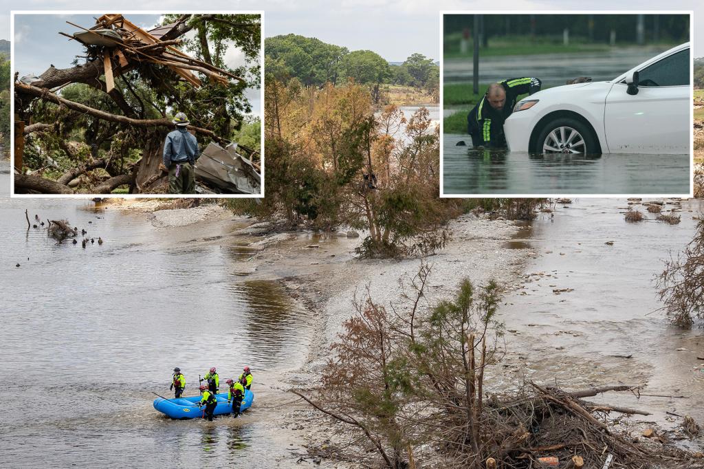
Emergency response teams are prepositioning assets based on FEMA’s new Flood Risk Assessment Matrix, which shows 34 counties with “high vulnerability” scores. “We’ve learned hard lessons from Hurricane Ida’s inland flooding,” says FEMA Regional Director Carl Mendez. “This event won’t have hurricane-force winds, but hydrostatic flooding could be just as deadly.”
Critical preparations underway include:
- National Guard deploying high-water rescue vehicles in Vermont
- Amtrak reducing speeds on Northeast Corridor routes
- Major airports adjusting schedules for anticipated wind shear
Urban areas face special challenges. New York City’s Emergency Management Department has activated its Flash Flood Emergency Plan, clearing 15,000 storm drains and positioning pumps in flood-prone subway stations. “We’re particularly concerned about basement apartments in Queens and Brooklyn,” warns Commissioner Zach Iscol.
Economic and Infrastructure Impacts Could Linger
The timing couldn’t be worse for fall tourism, with pumpkin patches, apple orchards, and foliage tours expecting record crowds. “We’re watching hourly forecasts,” says Vermont Tourism Director Sarah Bennett. “Many farms just recovered from July’s losses – another flood could be catastrophic for agritourism.”
Transportation analysts predict widespread disruptions:
- 30-60 minute delays on I-95 corridor
- Possible closures on secondary roads in the Catskills and Berkshires
- Freight rail impacts affecting fuel deliveries
Energy providers are bracing for outages. “Saturated ground plus 25-35 mph winds means trees will come down easier,” says Eversource VP Michael Hayhurst. The company has secured 1,000 additional line workers from unaffected regions.
Climate Connections: Is This the New Normal?
Climate scientists note this event fits troubling patterns. “Since 2000, the Northeast has seen a 55% increase in heavy precipitation events,” says Columbia Climate School’s Dr. Evelyn Cho. Warmer Atlantic waters are fueling these systems with 10-15% more moisture compared to 20th century storms.
While no single event can be attributed to climate change, the trend lines concern water management experts. “Our infrastructure was built for 20th century weather patterns,” notes Boston Water and Sewer Commissioner Olivia Park. “When you get back-to-back extreme events, recovery windows disappear.”
How Residents Can Stay Safe During the Deluge
Officials recommend these precautions:
- Charge medical devices and phones before Friday
- Move valuables from basement storage
- Avoid driving through flooded roads (just 12 inches of water can float most vehicles)
The Red Cross has opened pre-storm shelters in vulnerable communities. “Don’t wait for evacuation orders if you’re in a known flood zone,” advises spokesperson Denise Williams. “Identify your safe place now.”
As the region prepares for what could be its fourth major flood event in 18 months, resilience experts emphasize community connections. “Check on elderly neighbors,” suggests Mendez. “In prolonged events, isolation becomes dangerous.”
For real-time updates, residents should monitor National Weather Service alerts and local emergency management social media channels. With climate models predicting increased precipitation volatility, this weekend’s storm may offer sobering lessons about the Northeast’s wetter future.
See more Your Daily Weather