Atlantic Hurricane Season 2025: Could the First Storm Form Before June?
As the 2025 Atlantic hurricane season looms, meteorologists warn that the first named storm could develop before June—an unusual occurrence that may foreshadow heightened activity. Warmer-than-average sea surface temperatures and shifting climate patterns create favorable conditions for early cyclogenesis, raising concerns for coastal communities from the Caribbean to the southeastern U.S. Experts urge preparedness amid predictions of a potentially hyperactive season.
Unusual Early Activity Sparks Concern
Historical data shows only 18% of Atlantic hurricane seasons since 1851 produced a named storm before June 1, the official start date. However, the past decade has seen a 40% increase in such events, with 2023’s Tropical Storm Arlene forming on May 20. The National Oceanic and Atmospheric Administration (NOAA) reports sea surface temperatures in the Main Development Region (MDR) are currently 1.5°F above average—comparable to levels typically seen in mid-June.
“When you have bathwater-warm oceans this early, it’s like handing Mother Nature a loaded gun,” says Dr. Lisa Cheng, a senior researcher at Colorado State University’s Tropical Meteorology Project. “The atmosphere just needs the right trigger—a tropical wave or wind pattern shift—to fire that first shot.”
Factors Fueling Potential Early Development
Three key elements are converging to create ripe conditions for pre-season storm formation:
- Record Ocean Heat: The MDR stores 30% more thermal energy than the 1981-2010 average
- Weak Wind Shear: Upper-level winds that typically disrupt storm organization remain unusually calm
- African Easterly Waves: Early-season disturbances are forming 2-3 weeks ahead of schedule
Meanwhile, the fading El Niño pattern and potential La Niña transition by late summer could further reduce inhibiting wind shear. The European Centre for Medium-Range Weather Forecasts projects a 65% chance of La Niña development during peak hurricane months.
Preparedness Paradox: Complacency vs. Readiness
Emergency management officials face an uphill battle against “hurricane amnesia”—the tendency for coastal residents to underestimate risks after quiet seasons. The 2024 season produced only 14 named storms, lulling some communities into false security. Yet insurance data reveals 72% of hurricane-related claims since 2010 came from storms forming outside “peak season” (August-October).
“Early storms often catch people off-guard because school’s still in session and vacation plans aren’t finalized,” notes FEMA Regional Director Carlos Mendez. “We’re seeing garden centers selling out of generators in April this year—that’s the kind of proactive behavior we need.”
Technological Advances in Early Detection
New satellite networks and AI-driven modeling provide unprecedented forecasting lead times. The GOES-U satellite, launching June 2024, will offer real-time lightning mapping and improved storm structure analysis. Private firms like Climavision are deploying mobile radar systems to fill observational gaps in the Caribbean.
These tools helped accurately predict 2024’s early subtropical storm Alberto 10 days before formation. However, Dr. Cheng cautions: “Technology improves our vision, but doesn’t change the storms themselves. Earlier warnings only help if people act on them.”
Economic and Ecological Implications
An early-starting season carries distinct risks:
- Agriculture: Florida’s $7 billion citrus industry faces blossom damage from May storms
- Tourism: Cruise lines may reroute ships, affecting Caribbean economies
- Wildlife: Sea turtle nesting season coincides with potential beach erosion
Oil futures already reflect concern, with July contracts up 8% since March on potential Gulf of Mexico disruptions. Meanwhile, NOAA’s Coral Reef Watch reports bleaching conditions could worsen if storms stir up shallow, overheated waters.
What Coastal Residents Should Do Now
Experts recommend these preparedness steps before Memorial Day:
- Review evacuation routes—many coastal roads have changed since 2022’s hurricane damages
- Download the FEMA app with offline maps functionality
- Inventory home possessions for insurance claims using video documentation
- Test sump pumps and clear storm drains of spring debris
“Think of preparedness like baseball spring training,” advises Mendez. “You don’t wait until opening day to condition your body—communities shouldn’t wait until June to prepare.”
The Long-Range Forecast: Signs Point to Active Season
While April predictions carry inherent uncertainty, all major forecasting groups agree on elevated risk factors. The Tropical Meteorology Project’s preliminary outlook suggests:
- 18-22 named storms (average is 14)
- 9-11 hurricanes (average is 7)
- 4-6 major hurricanes (Category 3+)
These projections hinge on whether the current marine heat wave persists—a scenario growing more likely as ocean temperatures break records for 14 consecutive months. As climate change accelerates warming trends, scientists warn the very definition of “hurricane season” may need revision.
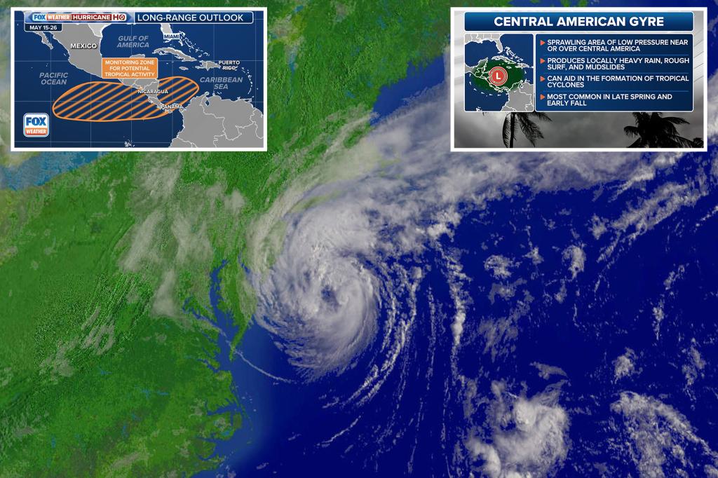
Coastal residents can stay informed through NOAA’s monthly outlook updates and state emergency management Twitter feeds. The next critical monitoring period begins May 15, when the National Hurricane Center starts regular tropical weather discussions regardless of storm activity.
See more Your Daily Weather