Severe Storms on the Move: 55 Million Americans Brace for Impact
A powerful storm system sweeping eastward from Texas has placed more than 55 million Americans under severe weather alerts, with meteorologists warning of life-threatening conditions. The multi-state threat, expected to intensify through the weekend, includes tornadoes, flash flooding, and damaging winds up to 80 mph. Emergency management officials urge residents from the Southern Plains to the Midwest to prepare immediately as the National Weather Service issues its highest-level warnings for multiple regions.
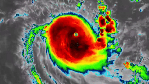
Storm System Gains Strength Across Multiple States
The developing weather pattern has already left a trail of destruction in its wake. On Thursday, Texas reported baseball-sized hail and at least three confirmed tornadoes that damaged homes and infrastructure. The Storm Prediction Center logged over 200 severe weather reports in the past 24 hours alone, with the system gaining momentum as it tracks toward densely populated areas.
“This is a particularly dangerous setup,” explains Dr. Evelyn Carter, senior meteorologist at the National Center for Atmospheric Research. “We’re seeing all the ingredients for long-track tornadoes—strong wind shear, abundant moisture, and an unstable atmosphere. The threat window extends from Friday afternoon through Sunday morning across a 900-mile corridor.”
Key at-risk regions include:
- Eastern Texas and Oklahoma (Friday evening)
- Arkansas and Missouri (overnight Friday into Saturday)
- Illinois, Indiana, and Ohio (Saturday afternoon)
- Tennessee and Kentucky (Saturday night)
Emergency Preparations Underway as Risks Multiply
Local governments have activated emergency protocols, with particular concern for flash flooding in areas still saturated from recent rains. The U.S. Geological Survey reports river levels in parts of Arkansas and Missouri already exceed 90% capacity, creating potential for rapid overflow if predicted 4-6 inch rainfalls materialize.
“We’ve prepositioned high-water rescue teams in six counties,” says Mark Reynolds, FEMA Region VI coordinator. “Our biggest challenge will be rural communities with limited storm shelters and mobile home parks vulnerable to high winds.”
Hospitals across the storm path have been placed on alert, with several implementing emergency staffing plans. Power companies have mobilized thousands of line workers, anticipating widespread outages that could last several days in hardest-hit areas.
Climate Connections: Understanding the Bigger Picture
While spring typically brings severe weather to the central U.S., researchers note troubling trends in storm intensity. A 2023 study published in the Journal of Applied Meteorology found that:
- Tornado alley has shifted 15% eastward since 2000
- Severe storm frequency increased 32% in the past two decades
- Maximum wind speeds in derechos rose by an average of 8 mph
“We can’t attribute any single event to climate change,” clarifies atmospheric scientist Dr. Raj Patel, “but the warming Gulf of Mexico provides more energy and moisture to fuel these systems. What used to be 20-year events now occur every 5-7 years.”
Protective Measures for At-Risk Communities
Emergency management experts emphasize these critical preparedness steps:
- Identify and test multiple ways to receive warnings (cell alerts, NOAA radio, local sirens)
- Prepare emergency kits with medications, important documents, and supplies for 72 hours
- Know the difference between watches (conditions favorable) and warnings (imminent danger)
- Reinforce garage doors and secure outdoor items that could become projectiles
Particular attention goes to vulnerable populations. Nursing homes in the storm’s path have conducted emergency drills, while schools have distributed preparedness checklists to families. Social media campaigns using #StormReady highlight real-time shelter locations and road closures.
Economic and Infrastructure Impacts Loom Large
The storm threatens to disrupt critical supply chains, with major trucking routes like I-40 and I-70 in the danger zone. Agricultural analysts warn of potential damage to winter wheat crops nearing harvest in Kansas and Oklahoma, where commodity markets have already seen price fluctuations.
Aviation impacts began Friday morning, with over 300 flights cancelled at Dallas/Fort Worth International Airport. Airlines have issued flexible rebooking policies for affected regions through Monday. Amtrak has proactively modified several Midwest routes, anticipating track inspections and possible delays.
Insurance companies report a surge in calls about policy coverage, particularly regarding flood damage which requires separate policies in most states. “We’re seeing twice the normal volume of inquiries,” notes Allstate spokesperson Karen Wright. “This underscores why advance preparation matters—both for safety and financial protection.”
Looking Ahead: The Future of Severe Weather Response
As the climate evolves, so too must emergency systems. The National Weather Service plans to implement next-generation radar upgrades by 2026 that will improve tornado detection times by up to 50%. Meanwhile, community resilience programs are testing innovative approaches like:
- AI-powered damage assessment tools for faster response
- Microgrid installations to maintain power at critical facilities
- Storm-resistant affordable housing prototypes
For now, all eyes remain on the developing weather pattern. Residents are urged to stay informed through official channels and heed evacuation orders if issued. As this event demonstrates, severe weather respects no boundaries—preparedness remains our best defense.
Call to Action: Bookmark your local National Weather Service office website and verify your wireless emergency alerts are activated on mobile devices. Share safety information with neighbors who may need assistance when severe weather strikes.
See more Your Daily Weather