Severe Easter Week Storms Loom Over Northeast: What You Need to Know
Millions of residents across the Northeast United States are bracing for a powerful storm system expected to bring high winds, thunderstorms, and potential hail during Easter week. Meteorologists warn the severe weather could disrupt travel plans, cause power outages, and pose safety risks from Wednesday through Friday. The National Weather Service (NWS) has issued advisories for parts of New York, Pennsylvania, New Jersey, and New England, urging preparedness as the system intensifies.
Timing and Potential Impacts of the Storm System
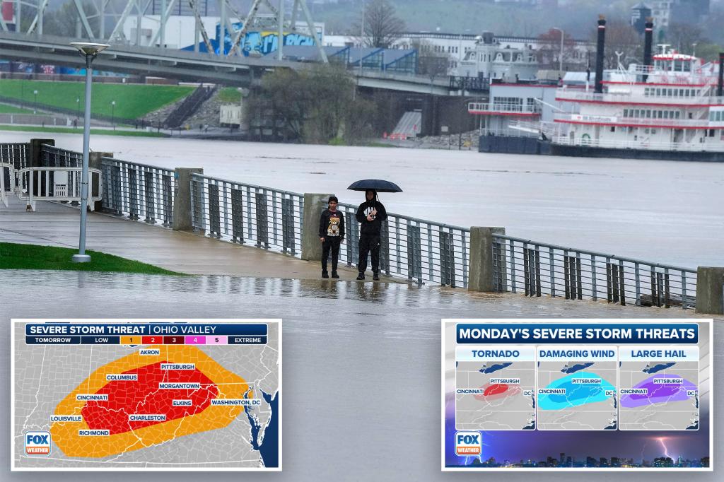
The storm is projected to follow a two-phase pattern, with the first wave arriving Wednesday evening and the second, more intense round hitting Thursday into Friday. Wind gusts could exceed 50 mph in coastal areas, while inland regions may experience torrential rain and isolated tornadoes. The NWS highlights that hail up to 1 inch in diameter is possible, particularly in western Pennsylvania and upstate New York.
“This system has the hallmarks of a classic nor’easter, but with added convective energy that raises the risk of severe thunderstorms,” said Dr. Laura Simmons, a senior meteorologist at WeatherTrack Solutions. “The combination of saturated ground from recent rains and strong winds increases the likelihood of downed trees and power lines.”
Key Regions at Risk and Preparedness Measures
Areas under the highest threat include:
- Coastal New England: Potential for flooding in low-lying areas due to storm surge.
- Eastern Pennsylvania: Elevated tornado risk amid unstable atmospheric conditions.
- New York City Metro: Flight delays and transit disruptions likely.
Local governments are preemptively deploying emergency resources. “We’re coordinating with utility companies to ensure rapid response teams are on standby,” stated Mark Reynolds, director of New Jersey’s Office of Emergency Management. Residents are advised to:
- Secure outdoor furniture and decorations.
- Charge electronic devices in case of outages.
- Avoid travel during peak storm hours Thursday afternoon.
How Climate Trends Are Influencing Easter Week Weather
Research from the National Oceanic and Atmospheric Administration (NOAA) indicates that spring storms in the Northeast have grown 15% more intense over the past decade due to warming ocean temperatures. This system aligns with that trend, as it draws moisture from an unusually warm Atlantic. “We’re seeing a higher frequency of these hybrid storms—part nor’easter, part severe thunderstorm complex,” noted Dr. Simmons.
While some critics argue that attributing individual storms to climate change is premature, data reveals a clear pattern. Spring rainfall in the region has increased by 20% since 2000, according to NOAA’s National Centers for Environmental Information.
Travel and Holiday Plans Face Uncertainty
With Easter Sunday falling just two days after the storm’s peak, families and religious groups are reevaluating gatherings. Airports from Boston to Philadelphia anticipate delays, and Amtrak has issued a flexible rescheduling policy for Thursday and Friday tickets. “We’re monitoring the forecast hourly,” said Denise Carter, a spokesperson for Newark Liberty International Airport. “Passengers should check their flight status before heading out.”
Road conditions may also deteriorate rapidly. State troopers in Massachusetts and Connecticut are increasing patrols to respond to accidents. “If you don’t need to be on the roads Thursday night, stay home,” urged Captain David Ruiz of the Connecticut State Police.
Long-Term Outlook and Safety Recommendations
Beyond this week, forecasters predict an active severe weather season for the Northeast, with above-average precipitation expected through May. Insurance agencies recommend reviewing property coverage for wind and flood damage, as claims in the region rose by 30% last spring.
For real-time updates, residents can download the FEMA app or follow local NWS social media channels. As the storm evolves, staying informed could mean the difference between safety and danger. Share this article with friends and family to spread awareness—preparedness starts with communication.
See more Your Daily Weather